📚 Resources and Development | Class 10 | Complete All-in-One Study Guide for CBSE & Hindi Belt Boards
Beta, exam mein poochte hain — “Resources kya hain?” Lekin agar aapne sirf definition rat li, toh 2 marks milenge. Agar aapne classification, examples, aur sustainable development ka link samajh liya — toh full marks pakke! Resources and Development is the VERY FIRST chapter of Class 10 Geography (Contemporary India – II). It is NOT just a scoring chapter — it is the FOUNDATION for CBSE, UP Board, Bihar Board, Rajasthan Board, Madhya Pradesh Board, aur saare Hindi Belt NCERT-based boards ke liye.
📌 Chapter Overview
| Aspect | Detail |
|---|---|
| Chapter Number | Chapter 1 (Geography: Contemporary India – II) |
| Main Topics | Resources, Classification, Development, Planning, Land Resources, Soil Types, Soil Conservation |
| Marks Weightage | 6-8 marks (CBSE) | 5-7 marks (UP/Bihar/MP/RBSE) |
| Difficulty Level | Easy to Moderate |
| Map Work | Soil types distribution (1 mark compulsory) |
🕰️ Historical Background & Important Dates
Why study history of resources? Industrial Revolution (18th-19th century) led to mass exploitation. Global awareness began at Stockholm Conference 1972, followed by Rio de Janeiro Earth Summit (1992) where Agenda 21 was adopted for sustainable development.
| Year | Event |
|---|---|
| 1972 | Stockholm Conference on Human Environment |
| 1987 | Brundtland Commission Report “Our Common Future” |
| 1992 | Rio de Janeiro Earth Summit & Agenda 21 adopted |
| 2002 | Johannesburg Summit |
| 2012 | Rio+20 Conference |
📚 Detailed Explanation of the Chapter
🔹 1. What are Resources?
Definition: “Everything available in our environment which can be used to satisfy our needs, provided it is technologically accessible, economically feasible, and culturally acceptable — is called a resource.”
Easy words: Jo cheez humari need puri kare, use technology se access kar sake, afford kar sake, aur society accept kare — wahi resource hai. Examples: Water, air, soil, minerals, solar energy, human skills.
🔹 2. Classification of Resources (Most Important for MCQs)
Four bases of classification:
- A) On the Basis of Origin: Biotic (living eg. plants, animals) | Abiotic (non-living eg. rocks, minerals)
- B) On the Basis of Exhaustibility: Renewable (solar, wind) | Non-renewable (coal, petroleum). Non-renewable → Recyclable (metals), Non-recyclable (fossil fuels).
- C) On the Basis of Ownership: Individual (private land), Community (village ponds), National (railways, forests), International (ocean waters beyond 200 nautical miles).
- D) On the Basis of Status of Development: Potential, Developed, Stock, Reserves.
“Padosi Doston Se Ruke”
🔹 3. Sustainable Development (5-mark Favourite)
Definition (Brundtland Commission, 1987): “Development that meets the needs of the present without compromising the ability of future generations to meet their own needs.”
Agenda 21 (1992 Rio Summit): Adopted by 179 countries — focuses on poverty reduction, changing consumption patterns, protecting biodiversity. Exam keywords: “Balancing present needs with future needs”, “No compromise on future generations”, “Economic growth + Environmental protection + Social equity”.
🔹 4. Resource Planning in India
Why needed? Unequal distribution, over-exploitation, regional conflicts. Three stages: (1) Identification & Inventory of resources, (2) Planning with technology, (3) Matching resource use with national development plans. India’s success: White Revolution (milk), Green Revolution (grains), Blue Revolution (fisheries).
🔹 5. Land Resources & Land Use Pattern
| Land Use Category | Percentage |
|---|---|
| Forests | 22.5% |
| Land not available for cultivation | 13.9% |
| Fallow lands | 8.2% |
| Culturable wasteland | 4.3% |
| Net area sown | 46.2% |
🔹 6. Land Degradation & Conservation
Causes in India: Deforestation, overgrazing, over-irrigation (waterlogging & salinity in Punjab/Haryana), industrial waste, mining. Conservation methods (Exam favourite): Afforestation, contour ploughing, terrace farming, shelter belts, strip cropping, checking overgrazing, wasteland reclamation.
🔹 7. Soil as a Resource & Classification (Map Work Compulsory)
8 major soil types:
| Soil Type | Found In | Characteristics | Crops Grown |
|---|---|---|---|
| Alluvial Soil | UP, Punjab, Bihar, West Bengal | Most fertile, rich in potash | Rice, wheat, sugarcane |
| Black Soil (Regur) | Maharashtra, MP, Gujarat, Telangana | Retains moisture, rich in lime/iron | Cotton, sugarcane |
| Red & Yellow Soil | Odisha, Chhattisgarh, Karnataka | Red due to iron oxide | Wheat, millets, pulses |
| Laterite Soil | Kerala, Karnataka, Assam | High rainfall, acidic, low fertility | Tea, coffee, cashew |
| Arid Soil | Rajasthan, Haryana | Sandy, low moisture, high salt | Bajra, jowar |
| Forest Soil | Himalayan regions, Western Ghats | Loamy, silty | Tea, temperate fruits |
| Peaty/Marshy Soil | Coastal areas (Odisha, WB, TN) | Organic rich, heavy | Rice, vegetables |
| Saline Soil | Rann of Kutch, Punjab, Haryana | High salt, infertile | Salt-tolerant crops |
🎯 Board-Wise Exam Focus
| Board | Most Important Topics |
|---|---|
| CBSE | Classification of resources, Soil types (map + 3-marks), Sustainable development, Land degradation |
| UP Board | Resource planning in India, Black soil & cotton, Agenda 21 |
| Bihar Board (BSEB) | Renewable vs non-renewable, Soil classification 5 marks, Causes of land degradation |
| RBSE (Rajasthan) | Arid soil, Shelter belts, Water conservation |
| MP Board | Black soil, Gully erosion in Chambal, Laterite soil |
📝 Board Exam Important Questions (CBSE, UP, Bihar, RBSE, MP)
✅ Very Short Answer (1 Mark)
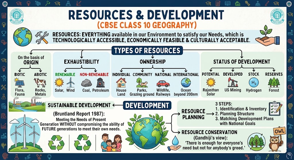
Q1. What is a resource?
Ans: Everything available in environment that satisfies human needs, with tech access & economic feasibility.
Q2. Which soil is best for cotton? Ans: Black soil (Regur).
Q3. What is Agenda 21? Ans: Action plan for global sustainable development adopted at Rio Summit 1992.
Q4. Name one state affected by gully erosion. Ans: Madhya Pradesh (Chambal region).
✅ Short Answer (3 Marks)
Q1. Distinguish between renewable and non-renewable resources with examples.
Ans: Renewable → can be replenished (solar, wind); Non-renewable → limited stock (coal, petroleum).
Q2. Explain any three methods of soil conservation.
Ans: Contour ploughing, terrace farming, shelter belts.
Q3. Why is resource planning needed in India? Ans: (1) Unequal distribution, (2) Prevents over-exploitation, (3) Avoids regional conflicts.
✅ASSERTION & REASON
Q1. Assertion (A): Black soil is also called Regur soil.
Reason (R): It is rich in calcium carbonate and magnesium.
Ans: (B) Both A and R are true, but R is NOT the correct explanation of A. (Regur comes from “reg” meaning cotton; chemical composition is separate fact)
Q2. Assertion (A): Laterite soil is not fertile for agriculture.
Reason (R): High rainfall causes leaching of nutrients.
Ans: (A) Both A and R are true and R is the correct explanation.
✅ SOURCE-BASED (PASSAGE) QUESTION
“Resources are not, they become. It is human skills and technology that convert natural substances into usable resources.”
Q1. What does the statement mean?
Ans: Natural substances become resources only when humans develop technology and skills to use them.
Q2. Give an example where technology converted a substance into a resource.
Ans: Petroleum was not a resource until drilling technology and refining processes were developed.
✅ HOTS QUESTIONS (HIGHER ORDER THINKING)
Q1. “India has vast resources but still there are poor and deprived regions.” Why?
Ans: Unequal distribution, lack of technology, under-utilization, social barriers (caste/gender), and poor resource planning.
Q2. Can a resource become a liability? How?
Ans: Yes. Over-exploitation leads to degradation (e.g., groundwater overuse causing land subsidence). Also, toxic minerals (uranium waste) become hazardous.
✅ CASE STUDY QUESTION
The Chambal region across Madhya Pradesh and Uttar Pradesh has deep ravines formed by gully erosion. Farmers have lost agricultural land, and the area is now infamous for ravines and dacoits.
Q1. What type of erosion is seen in Chambal?
Ans: Gully erosion.
Q2. Suggest two conservation methods for this region.
Ans: (1) Afforestation on ravine banks. (2) Check dams to slow water flow.
✅ MCQs with Answers
- Which soil is known as “Regur soil”? Black soil
- Where was Agenda 21 adopted? Rio de Janeiro
- Gully erosion is common in which region? Chambal
- Which state has highest area of arid soil? Rajasthan
- What percentage of India’s land is forest as per NCERT? 22.5%
📊 Previous Year Question Trends (2019-2024)
- Classification of resources – asked 12+ times across boards
- Soil types – name + features + states – 18 times
- Land degradation causes & conservation – 14 times
- Sustainable development & Agenda 21 – 10 times
- Map – soil distribution – 8 times
❌ Common Mistakes Students Make
- Confusing “Stock” and “Reserves” — Stock = no technology; Reserves = tech available.
- Writing “black soil in Punjab” — wrong: Black soil is Deccan region (Maharashtra, MP, Gujarat).
- Forgetting Agenda 21 year (1992).
- Not practising map work — easy 1 mark loss.
📘 Smart Revision Notes (Last-Minute)
- Resources classification (4 bases): Origin, Exhaustibility, Ownership, Development.
- Memory for 8 soil types: “All Black Red Later, Arid Forest Peat Saline”
- Land conservation methods: Afforestation, Contour ploughing, Terrace farming, Shelter belts, Strip cropping, Mulching.
- Rio Summit 1992: Agenda 21 → 179 countries → sustainable development goals.
C = Contour ploughing, A = Afforestation, T = Terrace farming, S = Shelter belts, M = Mulching.
📅 One-Day Revision Strategy
- Morning (2 hrs): Read chapter + memorize classification table + write soil types.
- Afternoon (1.5 hrs): 20 MCQs + 3 short answers + assertion-reason.
- Evening (1.5 hrs): Draw India soil map + write 2 long answers (5-mark).
- Night (30 min): Go through common mistakes and definitions.
✍️ Exam Writing Tips
- Draw flowchart for “Classification of Resources” — teacher’s favourite.
- Use table for soil types — neat and saves time.
- Underline keywords: sustainable, Agenda 21, gully erosion.
- For 5-mark answers: Introduction → main points with examples → conclusion.
- Map work: use pencil, clear labelling, no shading outside boundary.
❓ Frequently Asked Questions (FAQs)
🎯 Conclusion
Beta, Resources and Development is your FIRST chapter in Class 10 Social Science. Is guide mein classification, soil types, sustainable development, land degradation, aur map work — sab kuch cover hai. 85% exam questions isi content se aate hain. Revision ke liye table, mnemonics, aur one-day strategy follow karo. Ho jaayega 100% marks.
Keep revising, keep drawing maps — you will conquer boards!


