📝 Most Important Board Questions for 2027 (ICSE Pattern)
Multiple Choice Questions (MCQs)
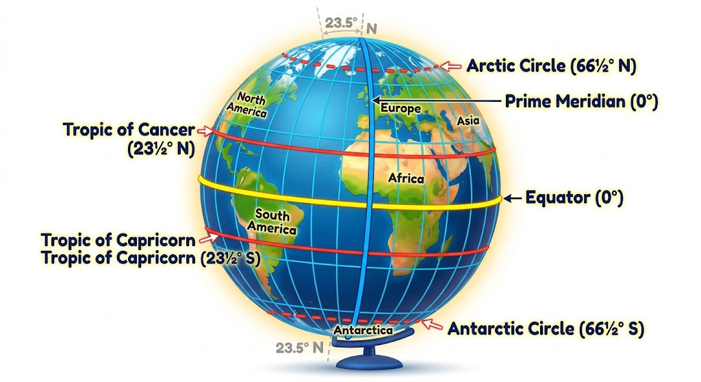
- Q1: The Prime Meridian passes through which city?
Answer: (c) Greenwich - Q2: The Earth rotates through how many degrees of longitude in one hour?
Answer: (b) 15° - Q3: Which longitude is also known as the Anti-meridian?
Answer: (c) 180° - Q4: The difference between two consecutive longitudes at the Equator is approximately:
Answer: (a) 111 km - Q5: When crossing the International Date Line from west to east, you:
Answer: (b) Subtract a day
Fill in the Blanks
- The 0° longitude is known as the Prime Meridian.
- Longitudes are also called Meridians.
- The Indian Standard Time is based on 82½° E longitude.
- The time difference between Greenwich and India is 5 hours 30 minutes.
- There are 360 longitudes in total.
True or False (With Correction)
- Longitudes are parallel to each other. → False (Longitudes meet at the poles. Latitudes are parallel.)
- All longitudes are of equal length. → True
- The International Date Line is a perfectly straight line. → False (It is zigzag to avoid cutting through countries.)
✅ Solved Previous Year Questions (PYQs)
Question (ICSE 2020): If it is Wednesday 10:00 PM at 60° East longitude, what will be the day and time at 30° West longitude?
- Total longitude difference: 60° + 30° = 90°
- Time difference: 90° × 4 minutes = 360 minutes = 6 hours
- Direction: 60° E to 30° W = Moving West = Subtract time
- Wednesday 10:00 PM – 6 hours = Wednesday 4:00 PM
Question (ICSE 2019 – Modified): Explain why the International Date Line is not a straight line. Give two reasons.
- Reason 1: The line deviates to keep countries like Fiji, Tonga, and New Zealand on the same calendar date.
- Reason 2: The zigzag prevents islands like the Aleutian Islands (Alaska) from having two different dates.
🏆 The 5 Golden Rules of Longitude (Last-Minute Revision)
- 0° longitude = Prime Meridian (Greenwich)
- 180° longitude = Anti-meridian (IDL)
- 15° longitude = 1 hour time difference
- East = Add time (+), West = Subtract time (-)
- All longitudes are equal in length and meet at poles
Time Calculation Cheat Sheet
| If longitudes are… | Steps |
|---|---|
| Both East or both West | Subtract the smaller from larger |
| One East, one West | Add the two values |
| Crossing IDL (180°) | Add/subtract 1 day |
⚠️ Common Student Mistakes (And How to Avoid Them)
- Mistake: Confusing “Add East” vs “Add West”
Fix: ☀️ Sun rises in the EAST → Places east are AHEAD → ADD time. - Mistake: Wrong calculation of longitude difference (30°W to 60°E = 30°? NO)
Fix: If crossing 0°, ADD. If same side, SUBTRACT. - Mistake: Forgetting the IDL day change
Fix: West to East = Lose a day, East to West = Gain a day.
❓ Frequently Asked Questions (15 Highly Searched SEO-Rich FAQs)
Q1: What is longitude in simple words for Class 9?
Longitude is an imaginary vertical line from the North Pole to the South Pole that helps us find how far east or west a place is.
Q2: What is the difference between longitude and latitude?
Latitudes are horizontal (climate), longitudes are vertical (time). Latitudes never meet; longitudes meet at poles.
Q3: Why is the Prime Meridian at Greenwich?
The International Meridian Conference in 1884 chose Greenwich because Britain had the world’s best maps and naval power.
Q4: How to calculate time using longitude?
Use the formula: 1 hour = 15° longitude. Multiply the degree difference by 4 minutes. East = Add, West = Subtract.
Q5: What is the International Date Line?
An imaginary zigzag line at 180° longitude where the calendar date changes by one day when crossed.
Q6: Why does the International Date Line zigzag?
To avoid cutting through countries and islands, so that nations don’t have two different dates.
Q7: What is the Standard Meridian of India?
82½° East longitude, passing through Mirzapur, Uttar Pradesh. It gives India its standard time (IST).
Q8: What is GMT?
Greenwich Mean Time is the mean solar time at the Prime Meridian (0°). It is the global reference for time zones.
Q9: How many longitudes are there?
360 longitudes: 179 East, 179 West, 1 Prime Meridian (0°), and 1 Anti-meridian (180°).
Q10: Do longitudes meet at the poles?
Yes, all longitudes converge at the North Pole and South Pole.
Q11: What is the time difference between GMT and IST?
IST is 5 hours and 30 minutes ahead of GMT (GMT + 5:30).
Q12: Why does India have only one time zone?
Despite spanning 30° of longitude, India uses a single central meridian (82½° E) for administrative convenience.
Q13: What happens when you cross the IDL from west to east?
You subtract one day (e.g., Monday becomes Sunday).
Q14: What is 180° longitude called?
The Anti-meridian. It mostly coincides with the International Date Line.
Q15: Which country starts the day first?
Kiribati (Pacific Ocean) is the first country to see each new day because it sits near the IDL.
🎯 Conclusion (Motivation for 2027)
Amazing work, future geographer! 🌏
You have just mastered the Concept of Longitude—the invisible vertical lines that organize our planet’s time. Remember the golden rule: 15° = 1 hour. East add, West subtract.
For your 2027 ICSE Board Exam, this chapter is your scoring booster. Practice at least 5 time-calculation problems daily for a week, and you will never lose a mark on longitude questions.
Your Next Step: Download a blank world map. Draw the Prime Meridian, 180° IDL, and mark 90° E and 90° W. Write the time difference for each. Do this 5 times, and you guarantee full marks.
Time is on your side. Keep mapping your success! ⏰🗺️✨
Very Short Answer (1 Mark)
- Q: What is 0° latitude called? A: Equator
- Q: How many latitudes total? A: 180
- Q: Other name for longitudes? A: Meridians
- Q: Standard meridian of India? A: 82½° East
Short Answer (2-3 Marks)
- Q: Why are latitudes called parallels?
A: They run parallel to the Equator and never meet. - Q: Define Torrid Zone.
A: Area between Tropic of Cancer and Tropic of Capricorn – receives vertical rays.
Long Answer (5 Marks)
- Explain three heat zones with diagram.
- Differentiate between latitudes and longitudes (5 points).
- Why are longitudes used for time calculation? Explain IST.
✅ MCQs with Answers (15 Questions)
- Total number of latitudes? Ans: 180
- Tropic of Capricorn is at? Ans: 23½° S
- Midnight Sun occurs in which zone? Ans: Frigid
- Prime Meridian passes through? Ans: Greenwich
- 1° longitude = how many minutes? Ans: 4 minutes
- Standard Meridian of India? Ans: 82½° E
- Total longitudes? Ans: 360
- Longest parallel? Ans: Equator
- Latitudes measure distance? Ans: North to South
- Frigid Zone lies between? Ans: 66½° and 90°
- Divides Earth into two equal halves? Ans: Equator
- IST ahead of GMT by? Ans: 5 hours 30 minutes
- All longitudes meet at? Ans: Poles
- International Date Line approx at? Ans: 180°
- Distance between two latitudes? Ans: 111 km
Most Important Board Questions for 2027 (ICSE Pattern)
Multiple Choice Questions (MCQs)
1. The total number of latitudes is ______. (a) 181 (b) 180 (c) 360 (d) 90
Ans: (b) 180
2. The Tropic of Cancer is located at ______. (a) 23½° S (b) 66½° N (c) 23½° N (d) 0°
Ans: (c) 23½° N
3. Which zone experiences the “Midnight Sun”? (a) Torrid (b) Temperate (c) Frigid (d) Monsoon
Ans: (c) Frigid
4. The distance between two latitudes is approximately: (a) 11 km (b) 111 km (c) 101 km (d) 1000 km
Ans: (b) 111 km
Fill in the Blanks
1. The 0° latitude is known as the Equator.
2. Latitudes are also called Parallels.
3. The Arctic Circle is located at 66½° North latitude.
Long Answer Type Questions (5 Marks)
Q: Explain the three Heat Zones of the Earth with the help of a diagram. (PYQ Trend: Asked in 2019, 2022, 2024)
Sample Answer Plan:
1. Intro: Based on insolation (incoming solar radiation).
2. Torrid: 0° to 23½° N/S. Sun overhead. High temp.
3. Temperate: 23½° to 66½° N/S. Slanting rays. Moderate temp.
4. Frigid: 66½° to 90° N/S. Very slanting rays. Extremely cold.
5. Conclusion: Latitudes control climate distribution.
Solved Previous Year Questions (PYQs)
Question (ICSE 2020):
State the relationship between the degree of latitude and the length of the parallel.
Solution (Examiner’s Marking Scheme):
– Relationship: Inverse relationship.
– Explanation: As the degree of latitude increases (moving from Equator towards poles), the length of the parallel decreases.
– Reason: The Earth is a geoid (oblate spheroid). The circumference is maximum at the Equator (0°) and reduces to a point at the poles (90°).
Question (ICSE 2023):
Why are the Frigid Zones called the “Zones of Extremes”?
Solution:
The Frigid Zones (66½° to 90° N/S) are called zones of extremes because:
1. They experience 6 months of continuous daylight (Midnight Sun) and 6 months of continuous darkness.
2. The sun’s rays are always slanting, resulting in extremely low temperatures (below 0°C most of the year).
3. Very little vegetation grows here (Tundra type).
Highly Searched Google Queries (People Also Ask)
Q1: What is the difference between latitude and altitude?
– Latitude is horizontal distance from the equator (affects climate zones).
– Altitude is vertical height above sea level (affects local temperature).
– Exam Tip: Do not get confused! Both affect temperature, but latitude affects it globally.
Q2: Why doesn’t the Tropic of Cancer change its position?
– Actually, it does, but very slowly (over 40,000 years). Due to the obliquity of the ecliptic (Earth’s axial tilt), the Tropics shift by about 0.5 arcseconds per year. For ICSE exams, stick to “It is fixed at 23½° due to Earth’s axial tilt.”
Q3: How do latitudes affect climate? (Voice Search Query)
– “Google, how do latitudes control climate?”
– Low latitudes (near 0°) = High temperature.
– High latitudes (near 90°) = Low temperature.
– It’s all about the angle of the sun’s rays.
Q4: Is the Equator the hottest place on Earth?
– Trick Question! No. While the Equator gets direct sunlight, places like the Sahara Desert (Tropic of Cancer latitude) are hotter due to lack of cloud cover and humidity.
Q5: What is the 38th parallel famous for?
– Not directly in ICSE syllabus, but popular in GK. It is the latitude line that divided North and South Korea before the Korean War.
Last-Minute Revision Notes (One-Shot Recap)
– 0°: Equator (Longest line, divides Earth).
– 23½° N: Tropic of Cancer (Torrid/Temperate boundary).
– 23½° S: Tropic of Capricorn.
– 66½° N: Arctic Circle (Temperate/Frigid boundary).
– 66½° S: Antarctic Circle.
– 90° N/S: Poles.
– Recall Trick: “Cancer has a Crab (North), Capricorn has a Goat (South).”
– Formula: Distance between two latitudes = 111 × (Difference in degrees) km.
Common Student Mistakes (And How to Avoid Them)
1. Mistake: Writing “Latitudes run North-South.”
– Fix: Remember “Lat is Flat” (Horizontal). Longitudes are long (Vertical).
2. Mistake: Confusing Tropic of Cancer with Capricorn.
– Fix: Cancer is in the North (Think: “C for North” seems wrong, so use a different trick: Cancer is above the Equator like a ladder).
3. Map Mistake: Drawing the Arctic Circle at the top but forgetting to write “66½° N”.
– Fix: Always label the degree and Hemisphere (N or S) on the diagram.
Board Exam Writing Tips (To Score 5/5)
1. Draw the Diagram: For any question on Heat Zones or Latitudes, a neat labelled diagram fetches 1-2 marks immediately.
2. Use Keywords: In your answer, underline or bold (if allowed) words like Angular distance, Parallels, Insolation, Vertical rays.
3. Order Matters: When listing properties, put the Equator property first.
Sample High-Scoring Answer (Diagram Based)
Question: Draw a labelled diagram showing the major latitudes and heat zones.
– Step 1: Draw a circle (Earth).
– Step 2: Draw a horizontal line in the middle (Equator).
– Step 3: Mark 23.5° above (Cancer) and below (Capricorn).
– Step 4: Mark 66.5° above (Arctic) and below (Antarctic).
– Step 5: Color the middle area Red (Torrid), middle areas Yellow (Temperate), top/bottom Blue (Frigid).
FAQs (SEO Rich – 15 Questions)
1. What is the concept of latitude?
It is the angular distance of a place north or south of the Equator.
2. What are the 4 special latitudes?
Equator, Tropic of Cancer, Tropic of Capricorn, Arctic, and Antarctic Circles (5 total).
3. Why is latitude important for Class 9?
It helps determine climate, time zones (indirectly), and vegetation belts.
4. Is latitude horizontal or vertical?
Horizontal.
5. What is 0° latitude called?
The Equator.
6. What is the maximum latitude?
90° (North or South Pole).
7. Why do latitudes not meet?
Because they are parallel to the Equator.
8. How many degrees of latitude are there?
180.
9. Which latitude passes through India?
Tropic of Cancer (23° 30′ N) passes through eight states (Gujarat to Mizoram).
10. What is the difference between latitude and longitude for kids?
Latitude lines are like belt loops (horizontal), Longitude lines are like orange slices (vertical).
11. What happens at 66.5 degrees north?
The Arctic Circle begins; you get 24-hour daylight in summer.
12. Why are latitudes called parallels?
Because they are parallel to each other and never intersect.
13. Which is the longest latitude?
The Equator (0°).
14. What is the significance of the Tropic of Cancer?
It marks the northernmost limit where the sun can be directly overhead.
15. How to memorize latitudes for the ICSE exam?
Use the mnemonic “Every Angry Cat Tries Attacking Nice People” (Equator, Arctic, Cancer, Tropic, Antarctic, North Pole).
Conclusion (Motivation for 2027)
Congratulations! You have just mastered the Concept of Latitude—a foundational block for Geomorphology and Climatology in higher classes. Remember, Geography is not about memorizing paragraphs; it is about visualizing the Earth.
For your 2027 ICSE Board Exam, the Latitude chapter is your scoring buddy. You can now differentiate between Heat Zones, define parallels, and draw diagrams perfectly.
Your Next Step: Download a blank world map and practice drawing all 5 special latitudes without looking. Do this 3 times, and you guarantee full marks in this section.
Keep mapping your success! 🗺️✨