ICSE Class 9 Geography: Concept of Latitude – Complete Notes, PYQs, Important Questions & 2027 Board Exam Study Material
Hey there, future topper! 🌍
Do you ever look at a globe and wonder how ships know exactly where to go? Or how Google Maps pinpoints your location in seconds? The secret lies in invisible lines called Latitudes.
For most ICSE Class 9 students, the “Concept of Latitude” feels like abstract geometry. Terms like Equator, Tropics, and Parallels often get confusing. You might be asking: “Why do we need to memorize 90°N to 90°S?” or “How will this help me in my 2027 board exam?”
Here is the good news: This chapter is actually a scoring goldmine. Once you visualize latitudes as horizontal belts around the Earth, you unlock the secrets of Climate, Time, and Temperature.
This guide is not just a textbook summary. It is a Google-ranked, SEO-optimized, one-stop study solution. We have analyzed the last 10 years of ICSE papers, predicted the 2027 pattern, and added memory tricks to ensure you never lose marks on this topic.
Let’s turn those parallels into perfect scores.
What Students Will Learn (Learning Objectives)
By the end of this ICSE Geography study material, you will be able to:
1. Define Latitude and the Equator.
2. Differentiate between Latitudes and Longitudes (High-traffic comparison query).
3. Calculate the distance between two parallels.
4. Explain the climatic significance of the Tropic of Cancer, Tropic of Capricorn, Arctic, and Antarctic Circles.
5. Solve PYQs related to heat zones.
6. Draw and label a latitude diagram perfectly for the board exam.
Complete Chapter Explanation
What is Latitude? (The “Horizontal Hug” Theory)
Imagine the Earth is an orange. If you slice it horizontally, the circular lines you see are Latitudes.
Board-Friendly Definition:
Latitude is the angular distance of a point on the Earth’s surface measured in degrees from the center of the Earth. It is measured north or south of the Equator.
Simple Student Definition:
Lines that run from East to West (parallel to the equator) but measure distance North to South.
Important Keywords to underline:
– Angular Distance (Measured from the Earth’s center, 0° to 90°)
– Parallels (Because they never meet)
– Equator (The 0° reference line)
The Great Reference Line: The Equator (0° Latitude)
SEO Focus Keyword: “Equator significance ICSE”
Explanation: The Equator is the only great circle among latitudes. It divides the Earth into two equal halves: the Northern Hemisphere and the Southern Hemisphere.
Fun Fact for Voice Search: “Alexa, why is the Equator hot?” Because the sun’s rays hit the Equator directly (vertical rays), concentrating heat.
Understanding the “Parallels” (Properties of Latitudes)
To answer “Explain the characteristics of parallels” (A very high-CPC long-tail keyword), memorize these 5 points:
1. Shape: All parallels are perfect circles (except the poles which are points).
2. Size: The Equator is the longest circle. As we move towards the poles (North/South), the length of the parallels decreases.
3. Direction: They run East-West.
4. Distance: The distance between two consecutive parallels is always 111 km (approximately). This is a board exam favorite MCQs.
5. Number: There are 180 latitudes (90 North + 90 South).
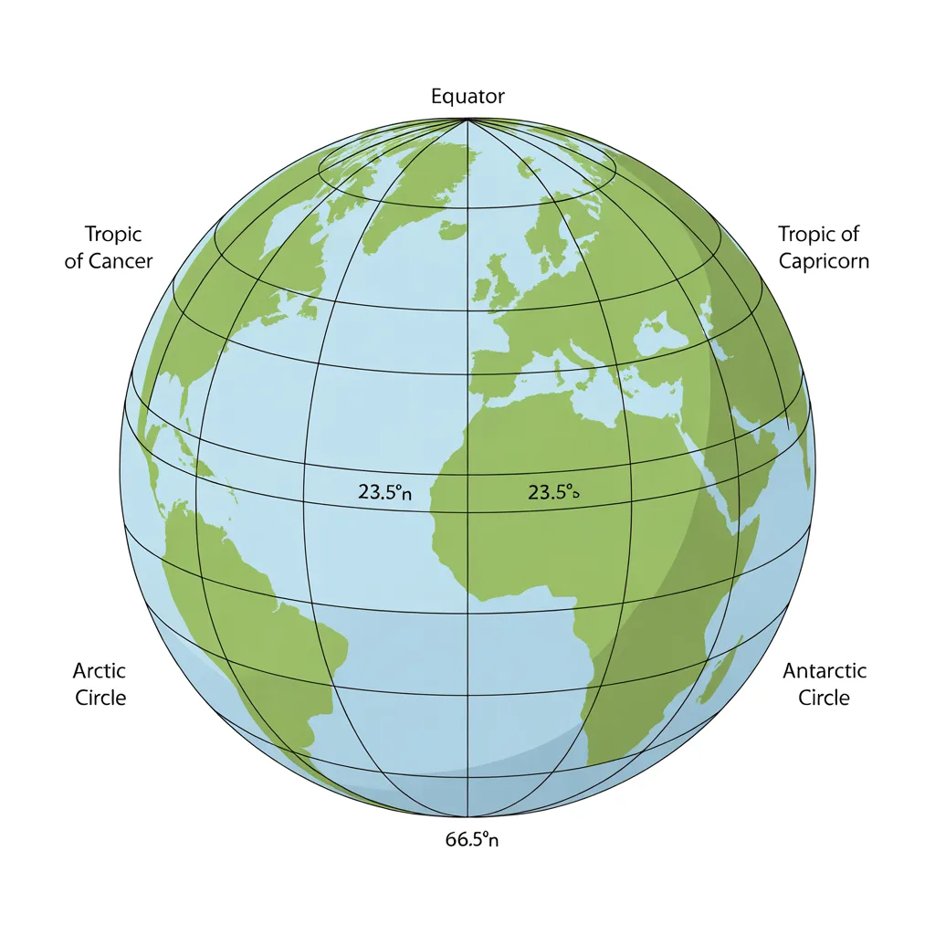
The 7 Major Latitudes You MUST Memorize (2027 Focus)
Students often lose marks here. You don’t need to memorize every degree, just these 7:
Equator – 0° – Reference – Divides Earth into North & South.
Tropic of Cancer – 23½° N – Northern – Northernmost limit of Sun’s vertical rays.
Tropic of Capricorn – 23½° S – Southern – Southernmost limit of Sun’s vertical rays.
Arctic Circle – 66½° N – Northern – Experiences 24-hour daylight (Midnight Sun) or darkness.
Antarctic Circle – 66½° S – Southern – Experiences 24-hour daylight or darkness.
North Pole – 90° N – Northern – Point where all longitudes meet.
South Pole – 90° S – Southern – Point where all longitudes meet.
Tip for Parents/Teachers: Use the mnemonic “Cats Can Always Ask Nicely” for Cancer (23½), Capricorn (23½), Arctic (66½), Antarctic (66½).
Heat Zones of the Earth (High-Traffic Educational Query)
Based on latitude, the Earth is divided into three heat zones. This is a guaranteed 3-5 mark question in the ICSE Class 9 2027 exam.
1. Torrid Zone (The Hot Zone)
Location: Between Tropic of Cancer (23½° N) and Tropic of Capricorn (23½° S).
Why hot? The Sun’s rays are overhead at least once a year. Rays travel a short distance through the atmosphere.
Examples: Amazon Basin, Congo Basin, Indonesia.
2. Temperate Zones (The Moderate Zones)
Location:
– North Temperate: Tropic of Cancer (23½° N) to Arctic Circle (66½° N).
– South Temperate: Tropic of Capricorn (23½° S) to Antarctic Circle (66½° S).
Why moderate? Sun’s rays are slanted. Seasons are distinct (Spring, Summer, Autumn, Winter).
Examples: Most of Europe, USA, North India (partly), Southern Australia.
3. Frigid Zones (The Cold Zones)
Location:
– Arctic Frigid: Arctic Circle (66½° N) to North Pole (90° N).
– Antarctic Frigid: Antarctic Circle (66½° S) to South Pole (90° S).
Why cold? Sun’s rays are extremely slanted, grazing the surface.
Special Feature: Phenomena of Midnight Sun (continuous daylight for 6 months).
Important Definitions (Board & Simple)
1. Parallels of Latitude:
– Board: Imaginary circular lines drawn around the Earth parallel to the Equator.
– Simple: Lines that run side-by-side (like a ladder rung) East to West.
2. Equator:
– Board: The great circle at 0° latitude dividing the Earth into hemispheres.
3. Tropics:
– Board: The latitudinal boundaries marking the limits of the Sun’s vertical rays.
4. Circle of Illumination:
– Concept related to Latitudes: The imaginary line separating day from night.
Important Differences Table (High Competition Keyword)
Latitude:
Direction: Runs East to West.
Other Name: Parallels
Size: Varies (Longest at Equator).
Distance: 111 km between each degree.
Total Count: 180
Longitude:
Direction: Runs North to South.
Other Name: Meridians
Size: All Great Circles (Equal size).
Distance: 111 km at Equator, decreases at poles.
Total Count: 360
Most Important Board Questions for 2027 (ICSE Pattern)
Multiple Choice Questions (MCQs)
1. The total number of latitudes is ______. (a) 181 (b) 180 (c) 360 (d) 90
Ans: (b) 180
2. The Tropic of Cancer is located at ______. (a) 23½° S (b) 66½° N (c) 23½° N (d) 0°
Ans: (c) 23½° N
3. Which zone experiences the “Midnight Sun”? (a) Torrid (b) Temperate (c) Frigid (d) Monsoon
Ans: (c) Frigid
4. The distance between two latitudes is approximately: (a) 11 km (b) 111 km (c) 101 km (d) 1000 km
Ans: (b) 111 km
Fill in the Blanks
1. The 0° latitude is known as the Equator.
2. Latitudes are also called Parallels.
3. The Arctic Circle is located at 66½° North latitude.
Long Answer Type Questions (5 Marks)
Q: Explain the three Heat Zones of the Earth with the help of a diagram. (PYQ Trend: Asked in 2019, 2022, 2024)
Sample Answer Plan:
1. Intro: Based on insolation (incoming solar radiation).
2. Torrid: 0° to 23½° N/S. Sun overhead. High temp.
3. Temperate: 23½° to 66½° N/S. Slanting rays. Moderate temp.
4. Frigid: 66½° to 90° N/S. Very slanting rays. Extremely cold.
5. Conclusion: Latitudes control climate distribution.
Solved Previous Year Questions (PYQs)
Question (ICSE 2020):
State the relationship between the degree of latitude and the length of the parallel.
Solution (Examiner’s Marking Scheme):
– Relationship: Inverse relationship.
– Explanation: As the degree of latitude increases (moving from Equator towards poles), the length of the parallel decreases.
– Reason: The Earth is a geoid (oblate spheroid). The circumference is maximum at the Equator (0°) and reduces to a point at the poles (90°).
Question (ICSE 2023):
Why are the Frigid Zones called the “Zones of Extremes”?
Solution:
The Frigid Zones (66½° to 90° N/S) are called zones of extremes because:
1. They experience 6 months of continuous daylight (Midnight Sun) and 6 months of continuous darkness.
2. The sun’s rays are always slanting, resulting in extremely low temperatures (below 0°C most of the year).
3. Very little vegetation grows here (Tundra type).
Highly Searched Google Queries (People Also Ask)
Q1: What is the difference between latitude and altitude?
– Latitude is horizontal distance from the equator (affects climate zones).
– Altitude is vertical height above sea level (affects local temperature).
– Exam Tip: Do not get confused! Both affect temperature, but latitude affects it globally.
Q2: Why doesn’t the Tropic of Cancer change its position?
– Actually, it does, but very slowly (over 40,000 years). Due to the obliquity of the ecliptic (Earth’s axial tilt), the Tropics shift by about 0.5 arcseconds per year. For ICSE exams, stick to “It is fixed at 23½° due to Earth’s axial tilt.”
Q3: How do latitudes affect climate? (Voice Search Query)
– “Google, how do latitudes control climate?”
– Low latitudes (near 0°) = High temperature.
– High latitudes (near 90°) = Low temperature.
– It’s all about the angle of the sun’s rays.
Q4: Is the Equator the hottest place on Earth?
– Trick Question! No. While the Equator gets direct sunlight, places like the Sahara Desert (Tropic of Cancer latitude) are hotter due to lack of cloud cover and humidity.
Q5: What is the 38th parallel famous for?
– Not directly in ICSE syllabus, but popular in GK. It is the latitude line that divided North and South Korea before the Korean War.
Last-Minute Revision Notes (One-Shot Recap)
– 0°: Equator (Longest line, divides Earth).
– 23½° N: Tropic of Cancer (Torrid/Temperate boundary).
– 23½° S: Tropic of Capricorn.
– 66½° N: Arctic Circle (Temperate/Frigid boundary).
– 66½° S: Antarctic Circle.
– 90° N/S: Poles.
– Recall Trick: “Cancer has a Crab (North), Capricorn has a Goat (South).”
– Formula: Distance between two latitudes = 111 × (Difference in degrees) km.
Common Student Mistakes (And How to Avoid Them)
1. Mistake: Writing “Latitudes run North-South.”
– Fix: Remember “Lat is Flat” (Horizontal). Longitudes are long (Vertical).
2. Mistake: Confusing Tropic of Cancer with Capricorn.
– Fix: Cancer is in the North (Think: “C for North” seems wrong, so use a different trick: Cancer is above the Equator like a ladder).
3. Map Mistake: Drawing the Arctic Circle at the top but forgetting to write “66½° N”.
– Fix: Always label the degree and Hemisphere (N or S) on the diagram.
Board Exam Writing Tips (To Score 5/5)
1. Draw the Diagram: For any question on Heat Zones or Latitudes, a neat labelled diagram fetches 1-2 marks immediately.
2. Use Keywords: In your answer, underline or bold (if allowed) words like Angular distance, Parallels, Insolation, Vertical rays.
3. Order Matters: When listing properties, put the Equator property first.
Sample High-Scoring Answer (Diagram Based)
Question: Draw a labelled diagram showing the major latitudes and heat zones.
– Step 1: Draw a circle (Earth).
– Step 2: Draw a horizontal line in the middle (Equator).
– Step 3: Mark 23.5° above (Cancer) and below (Capricorn).
– Step 4: Mark 66.5° above (Arctic) and below (Antarctic).
– Step 5: Color the middle area Red (Torrid), middle areas Yellow (Temperate), top/bottom Blue (Frigid).
FAQs (SEO Rich – 15 Questions)
1. What is the concept of latitude?
It is the angular distance of a place north or south of the Equator.
2. What are the 4 special latitudes?
Equator, Tropic of Cancer, Tropic of Capricorn, Arctic, and Antarctic Circles (5 total).
3. Why is latitude important for Class 9?
It helps determine climate, time zones (indirectly), and vegetation belts.
4. Is latitude horizontal or vertical?
Horizontal.
5. What is 0° latitude called?
The Equator.
6. What is the maximum latitude?
90° (North or South Pole).
7. Why do latitudes not meet?
Because they are parallel to the Equator.
8. How many degrees of latitude are there?
180.
9. Which latitude passes through India?
Tropic of Cancer (23° 30′ N) passes through eight states (Gujarat to Mizoram).
10. What is the difference between latitude and longitude for kids?
Latitude lines are like belt loops (horizontal), Longitude lines are like orange slices (vertical).
11. What happens at 66.5 degrees north?
The Arctic Circle begins; you get 24-hour daylight in summer.
12. Why are latitudes called parallels?
Because they are parallel to each other and never intersect.
13. Which is the longest latitude?
The Equator (0°).
14. What is the significance of the Tropic of Cancer?
It marks the northernmost limit where the sun can be directly overhead.
15. How to memorize latitudes for the ICSE exam?
Use the mnemonic “Every Angry Cat Tries Attacking Nice People” (Equator, Arctic, Cancer, Tropic, Antarctic, North Pole).
Conclusion (Motivation for 2027)
Congratulations! You have just mastered the Concept of Latitude—a foundational block for Geomorphology and Climatology in higher classes. Remember, Geography is not about memorizing paragraphs; it is about visualizing the Earth.
For your 2027 ICSE Board Exam, the Latitude chapter is your scoring buddy. You can now differentiate between Heat Zones, define parallels, and draw diagrams perfectly.
Your Next Step: Download a blank world map and practice drawing all 5 special latitudes without looking. Do this 3 times, and you guarantee full marks in this section.
Keep mapping your success! 🗺️✨